Alternate routes during St. Vrain Greenway trail closures
Alternate routes during St. Vrain Greenway trail closures
Updated 4/2019 to remove outdated weblink
Bicycling around Longmont is about more than recreation and fitness; it’s also a primary transportation method for many residents. Longmont’s greenway trail system offers multiple routes to help with commuting to work, completing errands, training for a race, or exploring our vibrant community.
What are cyclists (and pedestrians) to do when the routes they’ve become accustomed to experience long-term closures because of damage or construction? Whenever possible, the City of Longmont suggests alternate bike routes during longer closures and provides signs to point the way on these detours. These detours can incorporate a variety of route options:
- on-street striped bike lanes
- streets where bikes share the road with vehicles
- streets with wide shoulders
- sidepaths connecting bike trails (Note: Sidepaths are the wide concrete trails that are adjacent to major roads throughout Longmont)
- multi-use trails (concrete or soft surface)
Online Maps
Longmont’s online Trail Status Map and Bike Map are great resources to help with finding alternate routes. Both maps are available online at LongmontColorado.gov/trail-status.
The bike map details bike routes of all types throughout the city. The trail status map shows open trail sections and provides details on closures due to construction, high water, or other factors. Cyclists are encouraged to refer to these maps before heading on an unfamiliar route.
One current closure area is along the St. Vrain Greenway (SVG) trail from the Main Street Bridge east to the Left Hand Greenway (LHG). This section has been closed for safety and reconstruction while Resilient St. Vrain flood mitigation work takes place. A spring 2018 reopening date is currently planned for this portion of SVG.
Detour signs along this section route riders from the LHG trail to Martin Street and then either north on Martin Street or west toward Main Street along the sidepath that runs parallel to Ken Pratt Boulevard.
City of Longmont staff also suggest some other options that may help riders navigate around this closed area or simply explore new routes.
4th Avenue
For those looking to cross Main Street within the downtown area, staff suggest using 4th Avenue. Lower traffic speeds and density–combined with traffic signals and stop signs–make this a less-busy Main Street crossing.
1st Avenue
Consider using South Pratt Parkway rather than riding along Main. (The pedestrian bridge that crosses St. Vrain Creek near South Pratt is planned to remain open even as construction on that bridge begins later this year.)
Follow South Pratt north to 1st Avenue, and head east. (Use the frontage road that runs in front of Budget Home Supply, rather than the train overpass, which will deliver you to 2nd Avenue.) The traffic signal at 1st and Main will help you navigate that intersection. Stay on 1st until Martin Street, and then continue on your journey.
Boston Avenue
The recently opened Boston Avenue Connection between Main and Martin Streets is another alternative, especially if you won’t need to cross Main, or if you’re traveling during lighter traffic flows. This road has an on-street striped bike lane.
Left Hand Greenway
If your ride keeps you south of Ken Pratt Boulevard, check out the Left Hand Greenway (LHG). This nearly 3-mile trail starts at South Hover Street (where there’s also a nice connection to the LoBo Trail that runs along the Diagonal Highway toward Boulder). The LHG continues through Left Hand Creek Park, under Pike Road and along Missouri Avenue.
After passing Kanemoto Park, LHG runs under Main Street and passes the Longmont Recreation Center and Museum complex before joining back up with the St. Vrain Greenway beyond the current Resilient St. Vrain construction zone. From that point, riders also have the option to take a sidepath connection west along Ken Pratt Boulevard to shopping and dining areas located east of the Main Street/Ken Pratt Boulevard intersection.
 Try a New Route
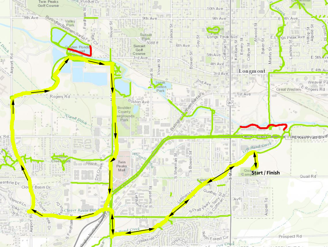
Looking for a new recreational route? Try this enjoyable, family-style ride that offers a mix of trails, dedicated cycling lanes, and quiet streets. This route is a staff favorite for a weekend morning.
Start at the Quail Complex (home to Longmont Museum and Recreation Center) and follow the LHG trail west. (You’ll pass under Main Street, Pike Road, and Hover Street.) On the west side of Hover, take the soft surface trail north to the new SH119 pedestrian underpass (just past Oskar Blues Liquids & Solids).
Once through the underpass, turn left on the sidepath toward the bus shelter on the Diagonal, and stay on the path as it jogs west to Dry Creek Drive/Pike Road. Cross the street here to the westbound on-street bike lanes, and continue heading west on this lightly traveled street across Fordham Street to Airport Road. At Airport, travel north on the sidepath to the Lykins Gulch Greenway trail, where you’ll head east.
When the Lykins Gulch Greenway connects with the SVG in less than a mile (still south of the St. Vrain Creek), continue east. Stay on the SVG trail under Hover, then make a sharp right turn to take the Hover sidepath south to the new Hover Street underpass at Dry Creek (at Village at the Peaks). Follow the underpass west under Hover and then continue south on the Hover sidepath to close the loop at the SH119 underpass.
Take Hover south to the Left Hand Greenway and follow it back to your starting point at the Quail Complex.
Share Your Secrets
How have you adjusted your routes during this closure along the St. Vrain Greenway trail? Have you discovered some new routes to enjoy in the meantime? Please share your tips for fellow travelers in the comment section below. We may share some your response on social media so others can benefit from your discoveries.
