
New Flood Insurance Rate Maps May Change Your Property’s Floodplain Status
The Federal Emergency Management Agency (FEMA) will officially adopt the new Flood Insurance Rate Maps (FIRMs) for Weld and Boulder Counties this fall. The Weld County FIRMs will become effective on Sept. 26, while the Boulder County FIRMs will become effective on Oct. 24.
Once they are effective, the official floodplain map will reflect these changes and some properties will change flood zone. Any building that will be in the 1% annual chance (100-year) floodplain and have a federally backed mortgage will be required to carry flood insurance. To check the flood zone for your property under the new maps, please visit the City of Longmont’s Floodplain Inquiry Map.
In addition, if your property is in the 1% annual chance (100-year) floodplain for the first time, your lender will let you know if you are required to get flood insurance. Your lender can still require you to have flood insurance even if your building is not shown in the 1% annual chance (100-year) floodplain.
The City of Longmont participates in the Community Rating System (CRS), and as such, residents qualify for a 25% discount on flood insurance premiums. Ask your insurance agent to provide a quote for flood insurance to you. You can find more information about flood insurance on the City’s Flood Insurance webpage.
You can also find more flood information, including frequently asked questions and preparedness and safety, at the City’s Flood Information webpage.
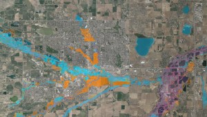
The Floodplain Map for Weld and Boulder Counties, will be officially be adopted in the fall of 2024.