Dickens Farm Nature Area
Dickens Farm Nature Area
Nature Area Hours: 1 hour before sunrise to 1 hour after sunset
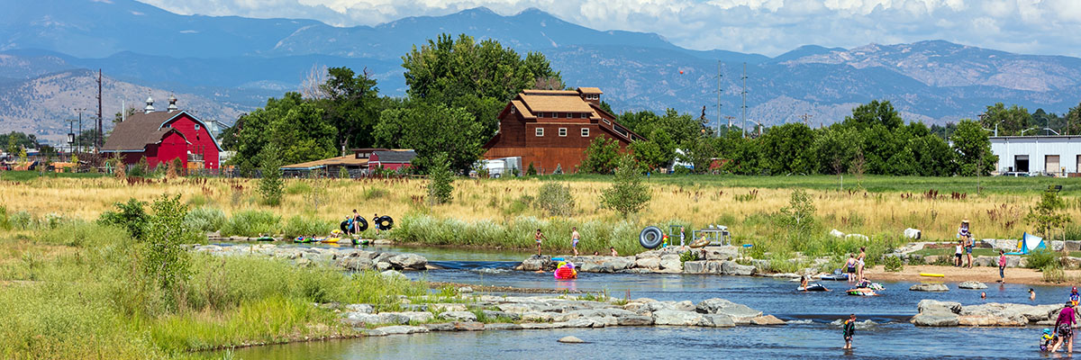
Dickens Farm Nature Area is an interactive nature area where the St. Vrain Creek runs right through. Located on a 52-acre site between Main and Martin Streets along the St. Vrain Creek, it is bordered by Boston Avenue to the north and is a trailhead for the St. Vrain Greenway trail system.
Nature area highlights include:
- ADA-accessible nature playground area and nature play discovery trail
- Beginner bike skills trail on easy rolling terrain and built with various trail materials
- Slower-moving water play areas
- Passive recreation areas
- Multiple shelter areas, including a large group shelter.
The nature area features native grasses, habitat areas for more environmental diversity, areas that improve water quality before it reaches the St. Vrain Cree, and access to the St. Vrain Creek. Historical and environmental interpretation areas include information on the Dickens family, pond ecology, and native fish.
Dickens Farm Nature Area was selected as the 2020 recipient of the “Parks and Trails” Award award for a large community given out by the Colorado chapter of the American Public Works Association (CO APWA).
Float Course
The jewel of Dickens Farm Nature Area is a float course along the St. Vrain Creek open to tubes, kayaks, paddleboards, and small, non-motorized boats. A designated open water access point at Main Street and takeout points east of Martin Street and at the 119th Street trailhead are marked by signs. There is no cost to use the St. Vrain Creek. Users must provide their own float devices (as listed above).
The distance from the access point at Main Street to the takeout just east of Martin Street is approximately 0.6 miles in the water and an approximate 0.75-mile walk from the takeout point back to the access point.
The float from Main Street to the 119th Street Trailhead takeout is approximately 1.5 miles with an approximately 1.8-mile walk back along the St. Vrain Greenway trail.
See a map detailing access points and takeout points.
Remember that any time you enter the creek, it is at your own risk. Learn more about recreational uses of the St. Vrain Creek
Parking
Parking options include a centrally located parking lot accessed from Boston Avenue and on-street parking along Boston. Public parking spots are available north of the Harvest Junction North shopping center (near Walgreens, Best Buy and Dick’s Sporting Goods). These public spots are labeled. Any other parking is at the user’s own risk.
There is no public parking located near the takeout downstream of Martin Street (near BioLife Plasma Services, Taco Bell and Hilton Garden Inn).
If desired, users can float past the Martin Street takeout to the 119th Street Trailhead, where an additional takeout point is located. Public parking is available at the 119th Street trailhead, which is located on the western side of 119th Street, south of Ken Pratt Boulevard and north of the St. Vrain Creek.
Artwork
The Art in Public Places Commission sought to honor the 2013 Flood with artwork that would celebrate resiliency, as well as the way the community and beyond came together during that difficult time. Artist Joshua Wiener was chosen by a selection panel with his proposal of “Rejuvenation,” celebrating the power of the water, the strength of the people and the community. This project has been installed in the Dickens Farm Nature Area and is scheduled to be dedicated in 2020.
History
The site was previously known as Pavlakis Open Space and was first master planned in 2001 as part of the St. Vrain Greenway Master Plan. The name Dickens Farm Park was adopted by the City Council at its July 9, 2013, meeting. Dickens was the original homesteader for the property and was a Longmont founder. The name was was updated to Dickens Farm Nature Area in 2016. The nature area fully opened in spring 2020.
Photo used courtesy of Confluent Design
Reservations and Permits
Plans, Maps and Reports
Renewal and Reinvestment
