Annual Water Main Line Flushing Program
Each spring, the City of Longmont water staff flushes the main water lines to keep water quality at its highest level and to ensure that fire hydrants are operational. The benefits realized in water quality and fire protection far outweigh the comparatively small amount of water released during the flushing program.
The 2025 dates for the flushing program are scheduled for Monday, April 28 through Friday, May 30 (dates subject to change.)
Residents may notice low water pressure, discolored water, or no water for short periods of time when flushing is taking place in their neighborhood. We recommend residents limit water use, and particularly avoid using hot water when flushing is occurring in their immediate area.
Find Frequently Asked Questions at the bottom of this page. For additional questions, please contact Water.
Know When We’re Coming And When We’re Finished
The Interactive Web Map below will tell you when we anticipate being in your neighborhood and which areas have been completed.
Note: All scheduling is provided as an estimate; changes may occur due to weather or other unforeseen circumstances.
Water Line Flushing Status Map
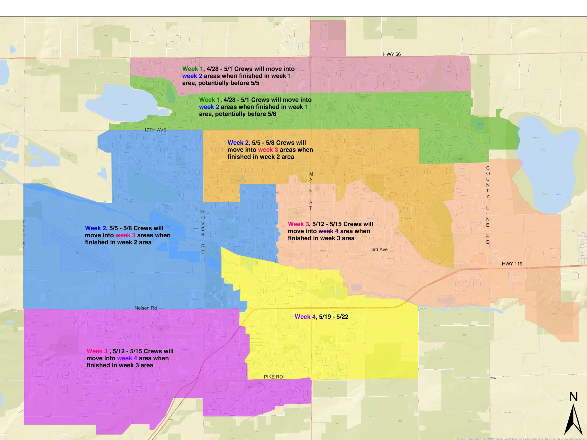
There are two maps below. The first is a static map of the flushing schedule for 2025. You can also view this map in a larger PDF format here. Please note that all scheduling is an estimate; changes may occur due to weather or other unforeseen circumstances. The second map is an interactive map that will show you areas of the City that have been completed.
Water Line Flushing Schedule for 2025
Water Line Flushing Interactive Map 2025
Water Line Flushing Schedule Map
Note: It may take a few seconds for the map and data to load. Having trouble viewing the map below? Open it in a new window.
Find your street manually
- Use the ‘+’ or ‘-‘ buttons on the top left corner of the map below to zoom in or out
- Find the street near you house and click on the line to view the flushing status and schedule
Find your street using the address search
- Type your address in the “Find address or place” search box in the top right corner of the map below
- Once your address is found on the map, click on the street line to view the flushing status and schedule
How to read the map
- Green: The area has been completed
- Gray: The area has not been completed
Staff will update the interactive map twice daily. Please check back often for up-to-date information.