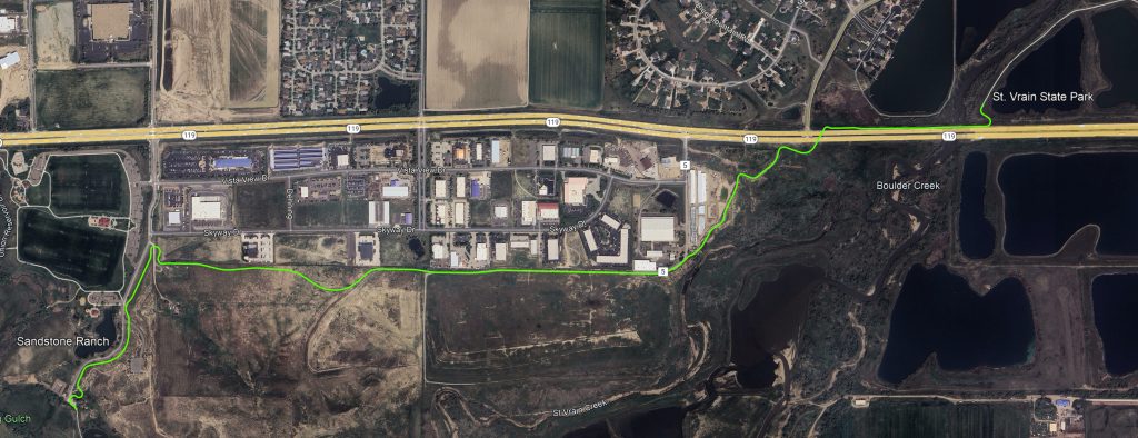
St. Vrain Greenway Phase 13 – Eastern Extension
Phase 13 will extend the St. Vrain Greenway trail more than 2 miles northeast from Sandstone Ranch Nature Area to St. Vrain State Park’s trail network, which ultimately connects to the Weld Legacy Trail east of I-25 in the Town of Firestone. The St. Vrain Greenway is also part of the statewide Colorado Front Range Trail, which is planned to extend from Wyoming to New Mexico.
Phase 13 will provide scenic overviews of City of Longmont Open Space and the St. Vrain Creek corridor and confluence with Boulder Creek, home to a variety of federally and/or state-listed species, as well as numerous raptors. Plans for the alignment include two bridges, including one north of Hwy 119 across St. Vrain Creek, as well as a culverted underpass beneath Hwy 119. This project is partially funded by a Denver Regional Council of Governments (DRCOG) Multimodal Options Funds (MMOF) Transportation Improvement Program (TIP) grant, which is administered by the Colorado Department of Transportation (CDOT).

After analyzing the feasibility of numerous trail alignments, the design team selected the current alignment because it:
-
- Reduces environmental impacts
- Complies with CDOT, Colorado Parks and Wildlife (CPW), U.S. Fish and Wildlife Service (USFWS), Federal Emergency Management Agency (FEMA), and U.S. Army Corps of Engineers (USACE) requirements
- Stays out of the St. Vrain Creek corridor
- Avoids work within 660 feet of active bald eagle nests
- Avoids placement of fill within the floodplain
- Leaves a large, contiguous City of Longmont Open Space area unfragmented
- Reduces environmental impacts
- Minimizes right-of-way acquisitions and the size of trail easements needed
- Meets ADA compliance, while providing a safe and scenic user experience
Phase 13 is one of the final two phases needed to complete the St. Vrain Greenway trail originally envisioned in the 1993 St. Vrain River Greenway Master Plan. Phase 12 will include a connection from Golden Ponds Nature Area west to Airport Road, completing the City of Longmont’s St. Vrain Greenway trail.
In 2001, the City of Longmont adopted the St. Vrain Greenway Master Plan – East Corridor Update. The 2001 update was the product of a collaborative effort between City of Longmont staff, consultant staff, key stakeholders, and local residents to provide an update to the original St. Vrain River Greenway Master Plan adopted in 1993. The 2001 update was undertaken to respond to changing circumstances within eastern Longmont and to refine the preferred vision for the trail from Main Street, east to the confluence with Boulder Creek. Portions of the St. Vrain Greenway trail west of Main Street to the City of Longmont’s Golden Ponds Nature Area were constructed in accordance with the 1993 Master Plan and prior to the 2001 update. The portions of the St. Vrain Greenway trail west of Golden Ponds Nature Area are addressed in the 2004 St. Vrain Trail Master Plan.
- Public Process – Completed, 2001 (as part of the St. Vrain Greenway Master Plan)
- Design Bid – Completed, summer 2021
- Design – In progress, began February 2022
- Construction Bid – Upcoming, expected early 2025
- Construction – Upcoming, expected 2025 – 2026
